Sentiero Spallanzani (Spallanzani Trail)
This trail is dedicated to the legacy of one of the most notable Italian scientists, Lazzaro Spallanzani, famously known for its studies in microbiology, physiology and biology.
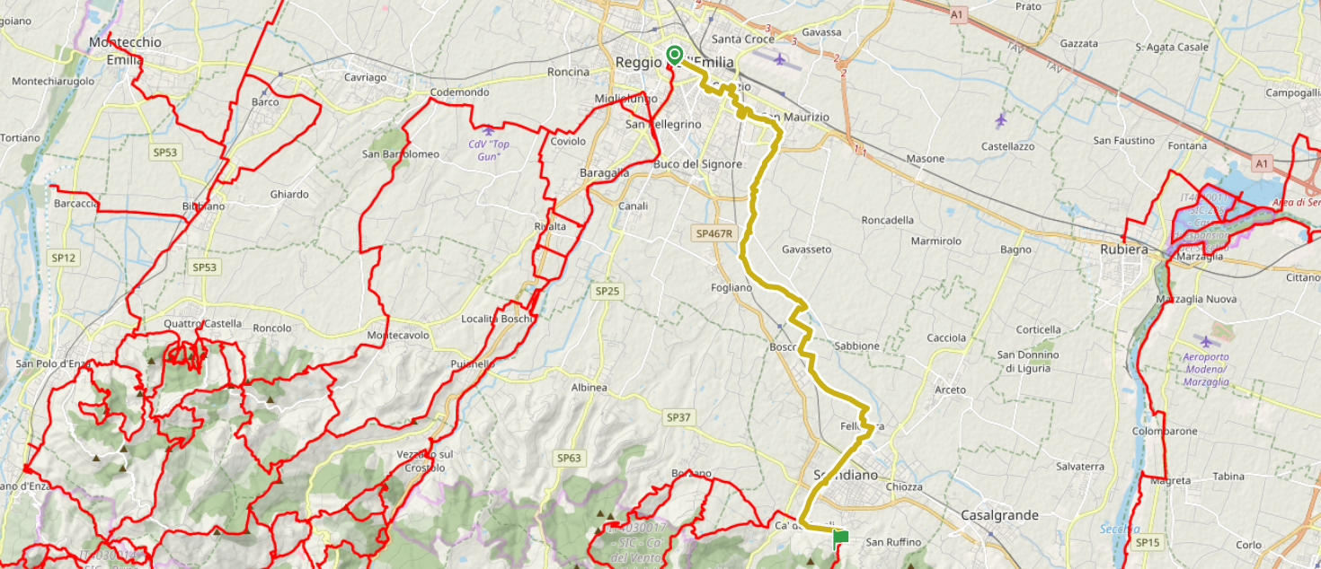
It is a medium difficulty mountain trail, with a maximum height of 1820 meters, 125 kms long and with a 5000 meters gain, starting from the City Museum of Reggio Emilia, where the Spallanzani Collection is preserved and exhibited to the general public. From the city center, the trail goes towards east, along the Rodano Stream Greenway, through the hamlet of Fellegara and arriving in Scandiano, the birthplace of Lazzaro Spallanzani.
All the trail can be followed in 8 days of trekking, or it can be discovered stage after stage, in order to slowly explore what the places can offer. In this factsheet there are in-depth analysis of the first two stages (From Reggio to Ventoso and from Ventoso to Regnano). For the other stages, there are detailed factsheets linked on the title on the official website of the trail.
All information can be found also on the official website of the Trail (only available in Italian): https://sentierospallanzani.it/
stages
1) FROM rEGGIO EMILIA TO VENTOSO (SCANDIANO MUNICIPALITY)
Length: 20.5 km
Medium difficulty
5 hours of walking
Places encountered: Reggio Emilia city center – Mauriziano (Ariosto's places) – Parco del Rodano – Canale di Secchia – La Giarola – Sabbione – Fellegara – Ca’ de Caroli – Scandiano
The trail starts into the city centre of Reggio Emilia, just in front of Palazzo dei Musei (City Museum), which stores the Spallanzani Collection, an impressive series of zoological, biological, lithological, botanical findings, catalogued upon Linnaeus's taxonomy method, along with the original furniture of Spallanzani's house.
After a tour through the major squares, the trail continues on Via Emilia San Pietro towards the former stadium of the city, Stadio Mirabello.
The trail transits near La Polveriera (the powder keg, ancient drill ground used until the 1940s as military facilities and now used as a center for communities and social events), and following the white and red signals until "Campo di Marte", a city park that was used back in the days as a drill ground for military, but now it a kids' favourite for its playgrounds and green spaces.
The trail then continues to Quinizio Park, crossing an interesting area of ecological compensation, representing what once was the Primitive Lowland Forest. Here there is a junction, taking the right turn we continue on the trail, while taking the left turn we can discover Mauriziano, the Ariosto's birthplace.
After turning on Via Metastasio, the pathway becomes entirely for pedestrians and connects itself to the path along the Rodano river. Shortly after there is another junction at the red bridge. Here you can cross the bridge and enter Acque Chiare Country-house, fantastic stop with rooms and restaurant available.
Our itinerary continues straight instead, following a good dirt road that enters the woods.
At the crossroad with Via Anna Frank turn right, cross the bridge on the Rodano river, and then cross the road that continues on the orographic left side of the river. Here you can see an important historic landmark: the Canale di Secchia, a manmade canal built by the Romans in order to bring freshwater into the city of Reggio Emilia. The canal was used until the 19th century, as merchants entered the city with small boats to drop their goods. Today is an irrigation canal for agriculture, but preserves its old fashion of ancient manufacture. In the event of closure of the Rodano bridge, you can cross the waterways using the metallic gangway of Canale di Secchia. In both cases, the trail continues onto the grassy side of the canal, some meters high on the ground level, admiring the plain from a higher point of view.
Continuing the route, we reach the paved road (Via del Bosco), near Gazo Bridge (Ponte del Gazo), once a historical battle place. Keeping on the right side, we follow the paved road and then continuing into the fields and into the vineyards, entering the property of Il Tralcio farm. We then arrive in Fellegara, small hamlet into the Scandiano territory. Here starts the Tresinaro river pedestrian walkway, reaching Cà dei Caroli. Here you can detour towards the historical centre of Scandiano, well-preserved and home to the Boiardo Castle and the birthplace of Lazzaro Spallanzani. Arriving in Cà dei Caroli we continue straight until the Via Resta Bridge. The trail continues on Via del Borgo for a kilometre and arrives in Ventoso hamlet. Here you can find the original starting point of Sentiero Spallanzani, as in 1988 started here.
Length: 18 km
Medium difficulty
5 hours of walking
Places encountered: Scandiano – Ventoso – Bottegaro – Colombaro – Rondinara – il Monte – La Minghetta – Castello di Viano (after 2h30 of walking) – S. Polo – Mamorra – Casino – Rio Faggiano (after 4h of walking) – Ca’ de Vezzoli – Regnano.
From the village of Ventoso, the starting point of Sentiero Spallanzani is easily recognisable, as it is located next to the west side of the ancient furnace. A dirt road climbs the Rio Guiglia creek, among bushes and wide grasslands. After having reached the crest of the hill (or watershed), we cross the pathway no. 604 (Monte Evangelo ring road) and we continue towards south-west, with a scenic view of the Tresinaro Valley hills. The trail crosses a farmstead (Bottegaro), and following the watershed ridge, continues on a slight slope among clay fields. During the spring season, in the grasses prairie, you can admire an impressive wild orchids bloom. After arriving in Case Monte di Sopra, we can admire the famous centuries-old oak tree, among the most beautiful trees in all Northern Italy. Returning onto the main path, we continue towards Colombaro, then reaching Rondinara. At a group of houses, the road becomes a dirt road, leading to the scenic Viano Castle, part of the Mathilda's domain defensive system. Continuing in Casina direction, after ~500 meters, we can find the parking lot with the signs for Salse di Regnano, cold mud volcanoes that form onto the surface, as deep in the ground there are pockets of methane and other gases. Lazzaro Spallanzani used to research here many times, as this area shows an impressive geological interest. At the end of the parking lot you can find the passage to reach the mud volcanoes, 100mt away from the road.
Length: 13 km
Medium difficulty
4h30mins of walking
Places encountered: Regnano – Monte Alfonso – Riolo di Montalto (after 1h of walking) – S. Giovanni di Querciola – Prediera (after 2h of walking) – Ca’ de’ Pazzi – Sorriva – Mulino del Tasso (after 3h of walking)– Monte delle Ripe – Case Mattioli – Giandeto.
4) From giandeto to carpineti
Length: 14 km
Medium difficulty
4h30mins of walking
Places encountered: Giandeto – Stropeda – Croveglia – Buramedia – Cerpiano (after 1h of walking) – Mulino delle Noci – Mandra – Pianzano (after 2h of walking)– Ca’ Spadaccini – S. Vitale (after 3h of walking) – Castello di Carpineti – Carpineti.
5) from carpineti to ginepreto
Length: 21.5 km
Medium difficulty
5h30mins of walking
Max height: 970 m
Places encountered: Carpineti – Castello di Carpineti – Ca’Fosola (after 1h30mins of walking) – Campogallinaro – Saccaggio – La Noce – Campolungo (after 3h30mins of walking) – Campo Pianelli – Pietra di Bismantova (after 5h of walking) – Ginepreto.
6) from GINEPRETO to LIGONCHIO
Length: 17 km
Medium-high difficulty
5h30mins of walking
Places encountered: Ginepreto – Ca’ Merlo – Ca’ Ceccarelli – Mulino di Vologno – Ponte del Pianello (after 1h of walking) – Ca’ Rabacchi – Monte Carù – Ca’ di Budriotto – Castellaro – Cerrè Sologno (after 3h of walking) – Montecagno – Casalino (after 4h30mins of walking) – Ligonchio.
7) from LIGONCHIO to RIFUGIO BATTISTI
Length: 14 km
Medium-high difficulty
5h of walking
Places encountered: Ligonchio – Presa Bassa – Presa Alta (2 h) – Passo di Romecchio (4 h) – Rifugio Bargetana – Rifugio Battisti
8) from RIFUGIO BATTISTI to S. PELLEGRINO IN ALPE
Length: 16 km
High difficulty
5h30mins of walking
Places encountered: Rifugio Battisti – Bocca di Massa (after 2h of walking) – Passo di delle Forbici (after 3h of walking) – Cima La Nuda – Colle dei Laghi – Passo delle Radici (after 4h30mins of walking) – Villa Bianchi – S. Pellegrino in Alpe. Gain: 400 m climb – 630 m down


 Did you enter our office?


