The Via Matildica del Volto Santo is a route that today allows travelers to retrace the ancient network of itineraries that crossed the territories of Countess Matilda of Tuscany.
The Via Matildica del Volto Santo is a 285-kilometer-long path that crosses the territory of three Italian regions (Lombardy, Emilia, Tuscany) rich in culture, traditions, and landscapes. A journey to discover the treasures of Matilda of Tuscany that runs alongside castles, parish churches, monasteries and abbeys, Renaissance cities, and medieval villages, from the Po plains, through the hills and mountains of the Tuscan-Emilian Apennine National Park, up to the valleys of the Garfagnana.
The person of Matilda of Canossa, a pivotal personality of the European Middle Ages, is directly linked to four emblematic places:
1. Mantua, the city that gave birth to Matilda of Canossa in 1046 ;
2. San Benedetto Po (Mantua province), in whose abbey she was buried before being moved to the Vatican;
3. Canossa (Reggio Emilia province), where the famous episode of the humiliation of Emperor Henry IV before Matilda took place in 1077;
4. Lucca, the city of origin of Matilda's family and home of the Volto Santo (an important 8th-century wooden crucifix).
The Via Matildica del Volto Santo is a great European route, which penetrates the cultural, historical, economic, and religious imagination of the Continent, a journey to discover the territories of Matilda of Tuscany to be followed in its entirety or divided into its three historical sections:
- La via del Preziosissimo Sangue, starting from Mantua to the historical centre of Reggio Emilia;
- Il Cammino di San Pellegrino, ancient pilgrimage road that stretches between the San Pellegrino Church in Reggio Emilia and the Sanctuary of San Pellegrino in Alpe;
- La Via del Volto Santo, old religious trail between San Pellegrino in Alpe and Lucca.
In ancient times, this network of itineraries that crossed northern Italy longitudinally was connected to the wider road network that connected the Papal States to the Germanic Kingdoms and Northern Europe.
Here, Matilda's Kingdom had the dual function of being both a defense of the papacy and a safe crossing point where caravans and connections could travel in the north-south direction of Europe and vice versa. The Matildic Way of the Holy Face was therefore part of a larger network of European road arteries that, during the Middle Ages, had to connect a large part of the European Continent.
The route can be followed in its entirety, with 11 total stages to be covered, or by choosing the stages closest to one's interests: spiritual, naturalistic, or historical-cultural. This route is meant to be traveled slowly on foot or by bicycle, rediscovering the places, the stopping stations, and the pace of the ancient medieval caravans.
The path meets other important routes, such as the Sentiero dei Ducati in the territory of Reggio Emilia, Vezzano sul Crostolo, Quattro Castella, and Canossa, and the Spallanzani Trail, near the Palazzo dei Musei in Reggio Emilia.
Discover all the stages on our Komoot profile and at the official website www.viamatildica.it .
Stage 1 - From Mantua to San Benedetto Po
The journey could not have a more glorious beginning: it starts from Mantua, a jewel of UNESCO. "Kilometer zero" is the majestic Basilica of Sant’Andrea, from which you will cross the beating heart of the city between Piazza Sordello and the imposing San Giorgio Castle.
Just outside the center, the noise of traffic gives way to the rustling of the reed beds. The route follows the shores of the Lower Lake (Lago Inferiore) and enters the Virgilian Wood (Bosco Virgiliano).
Pietole Vecchia: You will pass through ancient Andes, the birthplace of Virgil. Following placid waterways and pedestrian-cycle paths, you will cross the villages of San Biagio and Bagnolo San Vito, pedaling (or walking) immersed in the silence of the plains.
Continuing along the sinuous course of the Mincio, you will arrive in Governolo. It is a place full of charm: here, according to tradition, Pope Leo I halted the advance of Attila. There is also a tower, the remnant of an ancient small fortress that bears witness to the passage of the Great Countess Matilda.
After skirting the embankment of the Po, you will see the unmistakable profile of San Benedetto Po appear on the horizon. This village, dominated by the Polirone monastic complex commissioned by the Great Countess Matilda of Canossa, is one of the jewels of the itinerary.
Stage 2 - From San Benedetto Po to Guastalla
Leaving the Abbey of San Benedetto, the trail immediately takes you toward the heart of the Po. You will walk on secondary embankments that offer a privileged elevated position: from here, your gaze sweeps over the floodplains (golene), lands shaped by the river floods and human labor.
The section leading toward the bridge of Motteggiana (about 9 km) is a true test of "meditation in motion." The long straight stretches can be mentally demanding, especially if the sun is scorching, but do not fear: along the way, you will find support points and shade to catch your breath.
After returning to the embankment at Tabellano, the river keeps you company again for 7 km up to Luzzara.
Along the route, on your right, explore San Colombano Park: a natural area hiding surprising details linked to the Irish origins of the Saint.
You will then arrive in Luzzara, the town of the famous Cesare Zavattini, where the atmosphere seems to come straight out of a neorealist film.
Only 6 kilometers remain to make a triumphant entry into Piazza Mazzini in Guastalla. This ancient "little capital" of the Gonzagas will amaze you with its architectural elegance, a worthy end to an intense day filled with beauty.
Stage 3 - From Guastalla to Reggio Emilia
The walk resumes from Guastalla, slipping along the embankment of the Crostolo stream. It is a gentle start on a paved cycle path that takes you to Santa Vittoria in about 6 km. Here, a stop is a must to admire the imposing Palazzo Greppi, a testament to the rural grandeur of this land.
Immediately after Santa Vittoria, the route becomes wilder. You will leave the Crostolo to follow the Tassone Canal, a hydraulic work from the 1500s created to connect Reggio to the Po.
If you are walking in spring, the grass on the embankment might be high. In that case, descend toward Via Casaletto: it is a dirt road parallel to the embankment, much cooler and sheltered from the sun.
After crossing small villages and industrial zones that mark the approach to the city, and having crossed the Rodano stream over an ancient small brick bridge, you will suddenly find yourself in front of the Mediopadana Station by Santiago Calatrava.
The contrast is powerful: from the 16th-century land reclamations to the white steel "waves" of the High-Speed railway. It is the moment where peasant civilization shakes hands with the future.
An underpass will allow you to pass beneath the speed giants (the railway and the highway) to head straight for the historic center.
The entry into the city takes place via Via Roma, once a fundamental access gate for pilgrims.
From here, the route becomes triumphant: you will cross the splendid Piazza Martiri del 7 Luglio and finally enter Piazza Prampolini, the city's drawing room, where you can admire the Cathedral and the famous Sala del Tricolore.
Stage 4 - From Reggio Emilia to Canossa
The variant for Montalto, following the Path of San Pellegrino (Cammino di San Pellegrino), is also available. This stage can be found on the Via Matildica website and on the dedicated stage page of the Cammino di San Pellegrino.
This is the stage of the great change: the inclines increase and the shade decreases. If walking in summer, we recommend a departure at dawn.
The adventure begins at the San Pellegrino Bridge. For the first few kilometers, the route is a pleasant walk on the cycle path that follows the Crostolo stream, intersecting the large Park of the Reggia di Rivalta and the Corbelli Basin (Vasca di Corbelli) with Villa d’Este, a splendid example of pleasure architecture of the Este family, surrounded by water. You will continue through the greenery until reaching Vezzano sul Crostolo, where the city atmosphere definitively gives way to a hilly one.
After a stop at the Vezzano EcoPark (pay attention when crossing State Road 63/Statale 63), the real climb begins. A dirt road will lead to the summit of Monte Grafagnana.
Descending from the mountain, you reach Pecorile, where there is a fountain near the church. From here, the journey continues toward Casola Canossa. From Casola di Mezzo, there are 3 km of tiring ups and downs along the ridge. It is the final section, the wildest one, which will finally bring the destination into view.
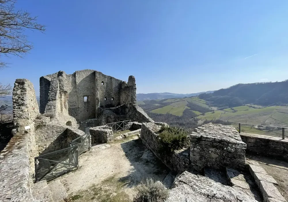
As soon as you emerge onto provincial road 73 (provinciale 73), the crag of Canossa appears in sight. A final flat kilometer separates you from the place where, in 1077, Emperor Henry IV waited three days in the snow to obtain the forgiveness of Pope Gregory VII, thanks to the mediation of Matilda.
Stage 5 - From Canossa to Carpineti
The continuation of the Montalto variant - Cammino di San Pellegrino is also available on the Via Matildica website and on the page dedicated to the stage of the Cammino di San Pellegrino.
You start under the shadow of the crag of Canossa, heading south. The first section is a plunge into the rural Middle Ages, crossing Cavandola and Cerredolo de' Coppi on dirt roads until reaching the splendid village of Bergogno.
Between Bergogno and Crocicchio, the trail immerses itself in the coolness of the Pentoma wood, a true lifesaver on the hottest days.
After passing small villages like Monchio, the trail climbs toward Sarzano Castle: from here, the view opens up 360 degrees over the peaks of the Reggio Apennines. It is one of the most iconic panoramic viewpoints of the entire journey. Descending from the castle, you enter Casina, the ideal place for a technical stop: here you will find all services, water fountains, and shops to restock your backpack. Leaving Casina, the route becomes evocative and "spiritual." You climb toward Marola, crossing its famous centuries-old chestnut groves. These monumental trees were the "bread" of the mountains for centuries. We then encounter the Marola Seminary with its abbey, a place of profound peace, before beginning the descent toward the valley. As you descend toward Carezza, you glimpse the imposing profile of Carpineti Castle – Matilda's favorite seat for her political decisions. Before arriving in the town, the trail leads to the church of San Donnino, nestled in a valley where absolute quiet reigns. A small pedestrian bridge will take you across the stream for the final stretch toward the center of Carpineti.
Stage 6 - From Carpineti to Toano
From Carpineti, you immediately head upward to reach the majestic Carpineti Castle. The ascent is among the most demanding of the journey: less than 2 km with an elevation gain of 200 meters. It is a challenging climb through the woods (note: some sections were affected by landslides in 2024). Once at the top, however, the view dominates the entire Apennines.
From the castle, you descend southward along a section shared with the Spallanzani Trail. Here the landscape changes its face, passing through the village of Savognatica and into a lunar scenery made of badlands (calanchi) and woods. It is an alternation of earth, grass, and brief paved sections that will give you the deepest silence of the Reggio mountains.
You then descend to the valley floor to meet the Secchia River.
The final section is pure rural poetry. From Cavola, you will follow dirt roads that connect villages where time seems to have stopped: Stiano, Corneto, and Manno are pearls of mountain architecture that deserve every extra step.
You arrive in Toano, the final destination with its thousand-year-old Pieve, one of the most beautiful and intact Romanesque monuments in Italy.
Stage 7 - From Toano to Gazzano
The walk sets off again from the splendid Pieve of Toano, starting with a flat path immersed in a fragrant pine forest.From the locality of Polcione, you will begin a decisive descent toward the heart of the valley.The Oratory of the Prevedelli: Following a dirt road that is steep in places, you reach the Oratory of the Prevedelli, nestled among the houses of Frale. Continuing parallel to the stream, you arrive at the famous Springs of Quara (Fonti di Quara), a perfect place to refresh yourself before tackling the Balze di Malpasso, a passage with an evocative name that offers breathtaking views of the bare rock.
At Ca’ di Gnano, the path branches into two routes, which rejoin upon arrival in Gazzano:
• The Classic Route (Reggio side): Continues toward Gova and Morsiano on quiet and panoramic roads.
• The Modena Variant: Crosses a suggestive medieval bridge to take the "Tracciolino," the old panoramic service road of the dam that leads to Gazzano, suspended between sky and water.
On the Reggio route, once you arrive in Morsiano, the walk becomes a river path, skirting the Dolo Stream and crossing the Rio Cervarolo on a modern metal and wood footbridge. From here, a final climb will finally lead to Gazzano, a village famous for its nativity scenes and high-mountain atmosphere.
From the locality of Polcione, you will begin a decisive descent toward the heart of the valley.
The Oratory of the Prevedelli: Following a dirt road that is steep in places, you reach the Oratory of the Prevedelli, nestled among the houses of Frale. Continuing parallel to the stream, you arrive at the famous Springs of Quara (Fonti di Quara), a perfect place to refresh yourself before tackling the Balze di Malpasso, a passage with an evocative name that offers breathtaking views of the bare rock.
At Ca’ di Gnano, the path branches into two routes, which rejoin upon arrival in Gazzano:
The Classic Route (Reggio side): Continues toward Gova and Morsiano on quiet and panoramic roads.
The Modena Variant: Crosses a suggestive medieval bridge to take the "Tracciolino," the old panoramic service road of the dam that leads to Gazzano, suspended between sky and water.
On the Reggio route, once you arrive in Morsiano, the walk becomes a river path, skirting the Dolo Stream and crossing the Rio Cervarolo on a modern metal and wood footbridge. From here, a final climb will finally lead to Gazzano, a village famous for its nativity scenes and high-mountain atmosphere.
Stage 8 - From Gazzano to San Pellegrino in Alpe
This stage starts from Gazzano, taking the ancient road to Civago. It is a shaded path rich in history, running parallel to the modern provincial road but immersed in the silence of the woods.
The first section will bring you coolness at the Fontana della Pila, the ideal place to refill water bottles before the climb. Shortly after, the trail skirts the Amorotto Tower (Torre dell'Amorotto), linked to the deeds of a famous 16th-century mountain bandit.
Having reached Civago, the last outpost of civilization, the ascent begins toward the wild heart of the Tuscan-Emilian Apennine National Park. You then reach the Segheria Refuge (Rifugio Segheria) at an altitude of 1,400 meters, nestled in one of the most beautiful fir woods in Italy. We then continue toward the Giovarello Pass and the Forbici Pass, the highest point of the entire Via Matildica (nearly 1,700 m). Here, your gaze sweeps from the giants of the Apennines to the sharp profile of the Apuan Alps.
From the Giovarello Pass, a panoramic descent begins along the Alta Via dei Parchi, past the Meadows of San Geminiano and the Radici Pass, walking on an invisible border that divides Emilia from Tuscany. The arrival at San Pellegrino in Alpe is located at an altitude of 1,525 meters. This village is a mystical place: here, time has stopped in the sanctuary that houses the remains of Saints Pellegrino and Bianco.
Stage 9 - From San Pellegrino in Alpe to Barga
Leaving the mystical San Pellegrino, we leave Emilia to enter Tuscan territory. You will take a dirt road on the right toward Valbona. The descent will lead straight to Castiglione di Garfagnana, one of the "Most Beautiful Villages in Italy" (Borghi più belli d'Italia), with its medieval walls and towers still intact.
Continuing toward Pieve Fosciana, if the weather is fine and the stream is calm, you can cross the water on foot; otherwise, a convenient bridge will take you into the village. From here, a cart track through the fields will quickly lead to Castelnuovo di Garfagnana. Cross the center, greet the Ariostesca Fortress, and pass over the Madonna del Ponte bridge. After Castelnuovo, a series of ups and downs begins that should not be underestimated, with a climb up Via Montealtissimo to a path in the woods that opens onto a breathtaking view of the valley, followed by the arrival in Cascio, a village famous for its walls and crisp focaccette.
A steep descent will take you to Gallicano. Here you will have to cross the Serchio River on the long road bridge. A final effort will lead you through the locality of San Bernardino up to Barga.
Stage 10 - From Barga to Borgo a Mozzano
You start from the Cathedral of Barga, one of the most panoramic points in Tuscany. Exiting through Porta Macchiaia, you follow the ancient aqueduct road.
After Buvicchia, the trail becomes wilder: a steep descent will lead to the ford of the Loppora stream. Shortly after, the Pieve of Loppia will appear, a masterpiece of Lucchese Romanesque architecture. Crossing country roads, you reach Ponte all’Ania. Here, a short but intense stretch leads to Piano di Coreglia, with Ghivizzano Alto in the background: with its castle and its intact tower, it is one of the most fascinating fortified villages in the valley. After descending from Ghivizzano, you cross the Serchio River on the road bridge. Once you reach the top of the Fortress (Rocca) with the final climb of the stage, a panoramic descent will accompany you to the entrance of Borgo a Mozzano. You enter the town through sections of asphalt and dirt road. Welcoming walkers is the undisputed symbol of this area: the Devil's Bridge (Ponte del Diavolo). With its asymmetrical arches, it defies the laws of gravity and history, marking the perfect end to this penultimate stage.
Stage 11 - From Borgo a Mozzano to Lucca
Leaving Borgo a Mozzano, the path winds toward the southeast. You will cross the valley through olive groves and villages, moving through an area well-served by the railway. Following dirt roads along the valley floor, you will reach Diecimo. Here stands the ancient Pieve of Santa Maria, a Romanesque jewel commissioned and built by Matilda of Canossa herself. The subsequent section crosses the industrial zone toward Valdottavo. This is a more anthropized and trafficked stretch. From here, however, you begin to climb toward San Donato and its ancient small church, immersed once again in the woods and silence.
Continuing between ridges and votive shrines, you will arrive in Aquilea. From here, your gaze finally sweeps toward the plain of Lucca on one side and the mountains on the other. A fast descent will lead you to Ponte a Moriano.
The final act is a triumphant ride of about 10 kilometers along the Serchio pedestrian-cycle path. It is a flat and relaxing route that will take you right beneath the majestic walls of Lucca. Enter the city, walk through the medieval streets, and reach the Cathedral of San Martino: there, in front of the legendary Volto Santo.