The Sentiero Spallanzani passes through all the vegetation zones of the Reggio Emilia Apennines, starting in Reggio Emilia and ending in S. Pellegrino in Alpe, on the Tuscan-Emilian ridge. Following in the footsteps of the famous Reggio Emilia-born scientist Lazzaro Spallanzani, this trail takes in all the climatic, geographical and biological zones of the Province of Reggio Emilia.
It is a route through ‘low’ and ‘mid-range’ mountain terrain, reaching a maximum altitude of 1,820 m, approximately 134 km long and with a total elevation gain of around 5,000 metres, starting in the historic centre of Reggio Emilia, home to the Spallanzani Collection.
The illustrious scientist from Scandiano donated his private collection to the municipality of Reggio Emilia; it can now be viewed at the Palazzo dei Musei. From the historic centre, the route continues eastwards along the Rodano Stream Greenway, passing through the village of Fellegara before reaching the municipality of Scandiano, the scientist’s birthplace.
The entire route can be covered in 7 days’ walking, or in sections, stage by stage, so you can discover its beauty at your own pace. All the routes and detailed itineraries are available on this page or at our Komoot profile.
Stage 1 - From Reggio Emilia to Scandiano
The route begins in the historic centre of Reggio Emilia, at the Palazzo dei Musei, which houses the Spallanzani Collection. After a brief tour of the main squares, the route continues along Via Emilia San Pietro, before heading towards the Ex Polveriera, the Campo di Marte sports area, Parco del Quinzio and Parco del Mauriziano. Leaving the city, the route becomes entirely for cyclists and pedestrians, linking up with the riverside path along the Rodano stream. A little further on, you reach the junction with the red bridge; continue straight on along an easy path that winds its way through the greenery.
A little further on, we come across an important historical feature: the Secchia Canal, an artificial waterway built by the Romans to bring water from the river into the city of Reggio Emilia.
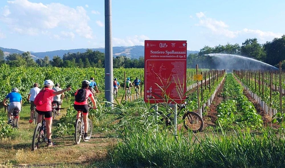
Continuing along the route, you reach the tarmac road at the Gazo Bridge, a site where an important battle once took place.
We carry on through fields and vineyards and, after passing through the centre of Fellegara, we reach the Tresinaro cycle and footpath, which leads to Ca’ de Caroli in Scandiano. Here, we turn off towards the historic centre, which is certainly worth a visit for its beautiful Rocca dei Boiardo and the birthplace of Lazzaro Spallanzani, from where the naturalist set off on his scientific excursions into the Apennines.
Stage 2 - From Scandiano to San Giovanni di Querciola
From the centre of Scandiano, we return to the Tresinaro cycle and footpath until we reach the hamlet of Ventoso, where the start of the trail is easily recognisable as it is situated near the western side of the former brickworks. A cart track winds its way up the valley of the Rio Guiglia through scrubland and wide grassy meadows.
Once you reach the watershed, you cross path with trail no. 604 (the Monte Evangelo loop) and continue south-west, enjoying sweeping views over the hills of the lower Tresinaro valley. Staying on the watershed, the path winds gently uphill amongst outcrops of flaky clay. In spring, numerous orchids bloom in the grassy meadows.
On reaching Case Monte di Sopra, you can admire the famous centuries-old oak (one of the finest specimens in Emilia). Return to the path towards Colombaro and continue to Rondinara. Upon reaching a group of houses, the road becomes a mule track and leads to the picturesque Castello di Viano, part of the Matildic defensive complex. Continuing towards Casina, after 500 metres on the left you’ll find the car park with a sign explaining the Salse di Regnano, small cold mud volcanoes bubbling in the clayey soil – a phenomenon caused by the underground presence of gaseous hydrocarbons.
Lazzaro Spallanzani had studied the Salse on several occasions, as a living testament to the region’s intense geological activity. Continuing along the route, we then arrive at San Giovanni di Querciola, a small village in the hills of Reggio Emilia.
Stage 3 - From San Giovanni di Querciola to San Vitale Parish
This section of the Spallanzani Trail forms part of one of the most picturesque routes in the Reggio Emilia Apennines.
The walk starts from the village of San Giovanni di Querciola, following a well-marked route that winds its way first along dirt tracks and country paths, passing through deciduous woods and grassy clearings teeming with biodiversity.
As you proceed, the route takes in characteristic sections of mule tracks and woodland paths, offering panoramic views over the valleys of the Rio Tresinaro and the surrounding hills.
The end point of this stage is the Pieve di San Vitale, an ancient place of worship dating back to the Middle Ages, with historical records tracing its origins as far back as the year 980.
Although this section of the route is not technically difficult, it requires careful attention to the signposts and a reasonable level of fitness, as it alternates between uphill sections and flatter stretches. It is advisable to tackle it in mild seasons such as spring or autumn, when nature displays its most intense and pleasing colours.
Stage 4 - From San Vitale Parish to Ginepreto
On this fourth day of the Spallanzani Trail, the journey on foot continues along one of the most scenic and nature-rich stretches of the entire route. From La Pieve, the trail winds along a ridge, passing through mixed woodlands of beech, chestnut and downy oak, and following ancient paths that once served as local transport routes.
Along the way, sweeping panoramic views of the Secchia Valley open up, whilst the distinctive silhouette of the Pietra di Bismantova dominates the horizon on clear days, creating a striking contrast between the plateaus and the valleys. The area is of geological interest, with rocks and natural formations that bear witness to millions of years of mountain history; the local flora and fauna – from the undergrowth to meadows and beech woods – offer an immersive experience of the Apennine countryside.
Along the route, you’ll come across Carpineti Castle, a medieval fortress built between the 10th and 11th centuries, which overlooks the surrounding valleys from its panoramic vantage point.
The stage ends in Ginepreto, a typical Apennine village at the foot of the Pietra di Bismantova.
Stage 5 - From Ginepreto to Ligonchio
Apennines; starting from the village of Ginepreto, the route winds its way along historic paths, mule tracks and through woodland.
The first part of the route descends gradually from Ginepreto towards the riverbed of the Secchia, following ancient mule tracks that pass through woodland and meadows.
Along this stretch, you can observe geological outcrops of great interest, in particular the characteristic Triassic gypsum formations, which form part of the UNESCO ‘Man and the Biosphere’ (MAB) programme for the Tuscan-Emilian Apennines National Park.
After crossing the Ponte del Pianello bridge, the route continues along dirt tracks and paths that climb up to a plateau covered in chestnut trees.
Along the way, you’ll come across ancient rural hamlets and picturesque villages such as Ca’ Rabacchi and Castellaro, perched on a hill of volcanic origin, which offers unique views over the intertwining valleys and hills.
After passing through areas of pasture and woodland, the trail passes through Montecagno and the traditional village of Casalino, before approaching the finish at Ligonchio.
Stage 6 - From Ligonchio to Rifugio Battisti
This sixth stage of the Spallanzani Trail reaches the Apennine Ridge, continuing on to the Cesare Battisti Mountain Hut at an altitude of 1,700 metres.
From the centre of Ligonchio, the trail initially follows shaded sections of path and forest tracks that wind along the valley of the Ozola stream. Here, centuries-old chestnut and beech trees grow in turn, and at certain times of year the ground may be damp and soft, whilst the alternation of clearings and woodland creates a succession of very picturesque natural environments.
Once past the Presa Alta area, the route begins to climb steeply towards higher altitudes. The path rises gradually until it reaches consistently high-mountain altitudes.
The central part of the stage follows paths that wind their way through beech woods and high-altitude meadows.
The stage culminates at the Cesare Battisti Mountain Hut, situated at an altitude of over 1,700 m, surrounded by the ridges and peaks that mark the Alpine heart of the Apennines.
Stage 7 - From Rifugio Battisti to San Pellegrino in Alpe
The seventh and final stage of the Spallanzani Trail, which follows the Apennine ridge – the border between Tuscany and Emilia – leading to the Sanctuary of San Pellegrino in Alpe, a crossroads between the provinces of Modena, Reggio Emilia and Lucca.
The day begins at the Battisti Mountain Hut, a landmark for walkers in the Apennines, nestled amongst beech woods and high-altitude meadows, with panoramic views of the surrounding peaks.
From the refuge, the trail follows ancient mountain paths, crossing green pastures and rocky areas, with views stretching down to the valley below and, on clear days, towards distant ridgelines. The route is marked with the classic red-and-white CAI signs and the abbreviation S.SP, which guide walkers through the varied natural landscapes that characterise the wildest and most evocative part of the Emilian Apennines.
On the descent, the path leads to San Pellegrino in Alpe, a small mountain village steeped in history and traditional architecture, as well as a junction for other trans-Apennine routes such as the Cammino di San Pellegrino and the Via Matildica del Volto Santo.