The Sentiero dei Ducati is a 201-kilometre route, starting in Reggio Emilia and ending beyond the Apennines in Liguria, passing through the ancient Matildic lands, the Duchies of Modena-Reggio and Parma-Piacenza, the Valle dei Cavalieri in the upper Val d’Enza, crossing the Passo del Lagastrello into the ancient Malaspina domains in Lunigiana, before reaching the countryside of the Republic of Genoa.
The route retraces the ancient borders of the House of Este amongst the duchies that ruled this territory between the 16th and 19th centuries, passing through a part of the Apennines as yet untouched by mass tourism, where unspoilt and wild landscapes can still be found, and where nature still reigns supreme.
A journey through history via marvellous places, rich in extraordinary archaeological, architectural and natural treasures: from the Matildic castles perched on the rolling hills overlooking the Po Valley, to the rugged mountain passes of the high Apennines, then on to Lunigiana with the Malaspina castles, passing through countless villages, enchanting parish churches, bridges and towers until reaching the elegant fortified town of Sarzana, skirting the ancient town of Luni, an important Roman port on the Tyrrhenian Sea.
The route
The Sentiero dei Ducati is a route that runs for 80 per cent of its length along footpaths, mule tracks, cart tracks or forest roads, through an almost untamed mountain landscape.
The best times to walk the trail are spring and autumn, when the days are long and the temperatures mild.
During wet periods, it is not uncommon to encounter mud, and some fords may be impassable in the event of heavy rainfall or snowmelt.
Along the route, you’ll encounter all the microclimates and landscapes that characterise this part of Emilia, from the industrious plain to the rolling hills of the Collina Reggiana, up to the ridges of the Apennines, the deep valleys of the Lunigiana, and the vast blue of the Ligurian Sea.
As this is a hiking route, it’s advisable to set off properly equipped for this type of activity and with a fitness level appropriate to the effort required.
The Sentiero dei Ducati comprises two routes: a walking trail and a cycle route for MTB or gravel bikes. The GPX tracks can be found on the Sentiero dei Ducati website.
Club Alpino Italiano (CAI, Italian Mountaineering Club) Reggio Emilia
Via Caduti delle Reggiane 1H (Zona Campovolo)
Phone: +39 0522 436685
cairesentierodeiducati@gmail.com
https://sentierodeiducati.it/
CAI Fivizzano
Via Variante Nord, 50 - 54013 Fivizzano (MS)
Phone: +39 347 960 8332
info@caifivizzano.it
https://www.caifivizzano.it/
CAI Sarzana
Piazza Firmafede 13 – 19038 Sarzana (SP)
Phone: +39 0187 625154
caisarzana@libero.it
https://caisarzana.com
You can purchase the official guide to the Sentiero dei Ducati (published by Terre di Mezzo Editore, available in Italian only), on sale in major bookshops and online stores.
At this link it is possible to download the official pilgrim’s passport here, or collect it from the IAT-R Office (Via Farini 1/A, Reggio Emilia) with your first stamp to mark the start of your journey.
Stage 1 - From Reggio Emilia to Quattro Castella
The first stage of the Sentiero dei Ducati starts from the historic centre of Reggio Emilia.
Historically part of the Duchy of Este, Reggio is a vibrant city with over three thousand years of history, from the ancient Regium Lepidi to its current status as a hub for contemporary art in Italy, with the complexes designed by Santiago Calatrava and the former Officine Reggiane.
Reggio Emilia is the City of the Tricolour, where, in 1797, the first flag of the Cisalpine Republic was designed in the green-white-red tricolour, which later became the Italian Tricolour in 1861. Discover the full history of Italy’s national symbol, recognised throughout the world, at the Museo del Tricolore, the only museum in Italy dedicated entirely to its flag.
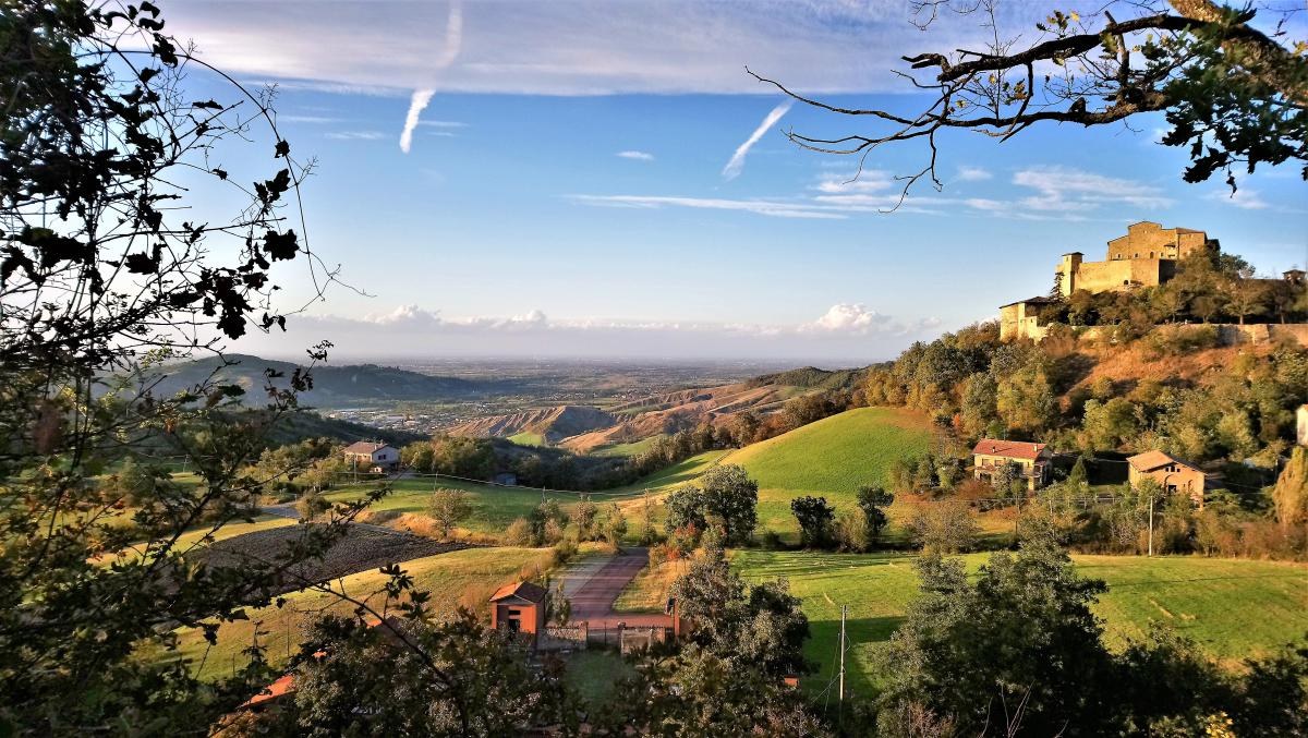
Following the city’s cycle paths and green corridors, you’ll reach Quattro Castella, a charming village nestled between the hills and the plains, overlooking the vast panorama of the Po Valley, which from here looks like an immense table dotted with villages.
Stage 2 - From Quattro Castella to Votigno di Canossa
The second stage of the Sentiero dei Ducati will take you on a journey to discover the heart of the Reggio Emilia hills and the Matildic Castles, including Bianello Castle and Canossa Castle – the residences of the Great Countess Matilda of Canossa – through peaceful valleys and tranquil medieval villages.
The final destination will be Votigno di Canossa, a village of medieval origin that has been transformed into a Buddhist retreat, an oasis of peace and tranquillity set amidst a landscape that is unique in the world.
Stage 3 - From Votigno di Canossa to Borzano d'Enza
The third stage of the Sentiero dei Ducati will continue within the Collina Reggiana and Terre Matildiche Special Protection Area and Protected Landscape, passing through enchanting places such as Vercallo, the Tassobbio Valley and the Church of Pianzo, before reaching the Big Bench at Trinità di Casina, from where you can admire a breathtaking view of the Enza Valley.
Stage 4 - From Borzano d'Enza to Vetto
The fourth stage of the Sentiero dei Ducati route takes you into the Enza Valley, passing through the mountain range comprising Mount Luiseto, Mount Pineto and Mount Marola, before reaching the village of Vetto. This is a relatively short stage, also suitable for a day trip to discover a hidden corner of the province of Reggio Emilia.
Stage 5 - From Vetto to Castagneto
The fifth stage of the Sentiero dei Ducati. We are in the upper-middle Val d’Enza. We pass through the woods and along the paths between the small villages of Gottano, Cereggio and Taviano. Between the latter two, we take a detour (Trail 640A) which leads us to the Arenarie di Ranzano, sandstone rock formations known as ‘Pizzoni’ – stones with distinctive shapes, formed by erosion from water and the elements. This site forms part of the Emilia-Romagna Region’s Canale delle Vigne Protected Geosite, and is also the gateway to the Valle dei Cavalieri, a magical spot in the upper Val d’Enza and Valcieca in the Parma Apennines.
Stage 6 - From Castagneto to Succiso Nuovo
Stage six of the Sentiero dei Ducati. We enter the highest part of the Emilian Apennines, where we can see the great mountain ranges of the Anti-Apennines and the Crinale. Along the way, we pass through two small villages: Succiso Nuovo and Fornolo, but almost the entire stage takes us through isolated areas bathed in silence.
Stage 7 - From Succiso Nuovo to Miscoso
The seventh stage of the Sentiero dei Ducati, where we approach the high-altitude section of this route. The landscape is that of the high mountains, with beech woods and lakes. Take care at the 1.3-kilometre mark at the ford across the Liocca stream, especially in spring and autumn.
Stage 8 - From Miscoso to Sassalbo
The eighth stage of the Sentiero dei Ducati, with the route passing through high-altitude sections at 1,200 metres above sea level at the Passo del Giogo and the Passo del Lagastrello. As we cross these heights, we leave Emilia behind and enter Tuscany, but we also cross the bioclimatic boundary that separates continental Europe from the Mediterranean region.
The route winds through the shade of large beech woods, before gradually descending through centuries-old oak and chestnut groves. Take care at the many stream crossings.
Stage 9 - From Sassalbo to Casola in Lunigiana
Ninth stage of the Sentiero dei Ducati, where the long distances begin, as we pass through areas with very little human presence. We encounter significant elevation changes and few refreshment stops along the way. This is the first stage entirely within Tuscany and offers sweeping views of the Apuan Alps, passing through centuries-old chestnut groves and the first olive groves, taking us practically into the heart of Lunigiana. The trail partly coincides with the route of the Trekking Lunigiana.
Stage 10 - From Casola in Lunigiana to Fosdinovo
The tenth and penultimate stage of the Sentiero dei Ducati – the longest of the route – reveals all the beauty and charm of the most authentic Lunigiana, running along the western slopes of the Apuan Alps, right at the foot of the Pizzo D’Uccello massif. We pass through places of extraordinary interest, such as the caves of Equi Terme, and also travel close to the railway line linking Aulla with Lucca.
Stage 11 - From Fosdinovo to Sarzana/Luni
The eleventh and final stage of the Sentiero dei Ducati, links the Apuan Alps to the sea, which can already be glimpsed from the fortress in Fosdinovo. The original route ends at Sarzana, but by taking a detour we can reach ancient Luni, a settlement inhabited by peoples before Romans and later colonised by them. A short distance away, we can reach the beaches of Fiumaretta, bringing our journey from the Grande Pianura to the Ligurian Sea to a close.